
Maps, maps, and more maps
Here is a selection of maps I have made over the years, including items I have made as part of my employment which I can share.

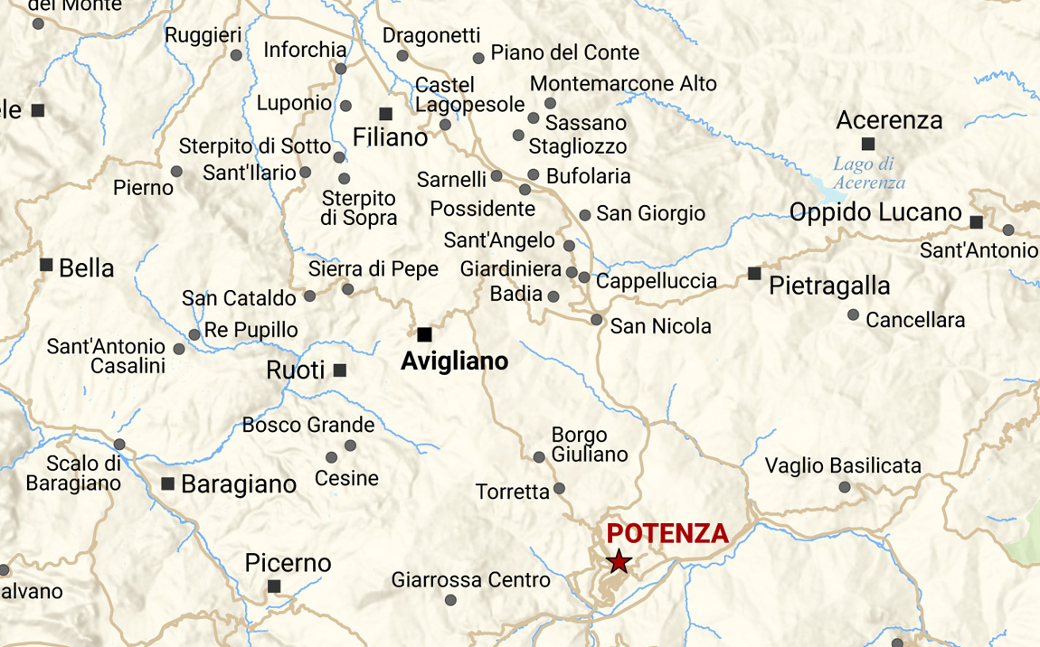
Italia map series
Back in 2022, I downloaded some data to create a map of Calabria, Italy, which is where my mother-in-law was born. It was a way for me to get some practice in using Esri’s ArcGIS Pro, since at work we were still heavily reliant on ArcMap.
The first version of the Calabria map was fairly basic. I shared it with an Australian Calabrese group on Facebook and had many requests to add additional villages. I promised I would then work on a map of Basilicata (where my father-in-law is from) but that didn’t eventuate until a couple of years later when I picked up the project again.
I added national parks, rivers and lakes, and changed the structure of the locality symbology and annotation. In 2024, I had a version of both regions where lots of places had been added after I painstakingly compared Google Earth imagery and looked up localities on Wikipedia, as the data I had downloaded was not extensive enough. I reviewed the maps once again in 2025 and realised I had gone too far! It was way too detailed, so I removed a lot of my previous work and also ensured that every single comune was labelled on the maps. Anything extra I could fit on the map was a bonus.
The Calabria and Basilicata maps were finally completed in December 2025. I am currently working on a similar-style map of Sicilia, and I will then work on Puglia. I haven’t yet decided if I’ll do all regions of Italy, but vediamo (we’ll see)!


Country maps

Some maps of various countries I have made over the years. Currently in progress is a map of Türkiye, similar in style to the United Kingdom map.

Map showing Italy’s regions, their capitals, and major cities. This is a plain design, but I like the colours and fonts I chose, and I could label all the regions comfortably.
Downloads
Italy region map PNG (2.71 MB)
Italy region map PDF (363 KB)

Map showing the counties of the United Kingdom and major cities. I didn’t go into too much detail on this one. I wanted to label each county, but was surprised at how many there actually were!
Downloads
UK county map JPG (2.02 MB)
UK county map PDF (373 KB)

This simple world map was created for a report on uranium for work, but it never ended up being used in the document. I think the graphics ended up being provided externally.
I enjoyed making it because it’s not something I get to do often in my job; usually the maps I make are focussed on South Australia (see next section).
I believe the projection was Gall Stereographic (boo to Mercator!) and centred Australia deliberately to make it the focus.
Downloads
Global uranium reserves map JPG (460 KB)
Global uranium reserves map PDF (234 KB)

South Australia maps
Here is a small selection of maps I have produced as part of my employment with the Department for Energy and Mining (DEM). A lot of my work goes into publicly available publications or is displayed in presentations my colleagues make at conferences. Sometimes, I make a map that never ends up seeing the light of day (this is rare, thankfully!).

This is a map made for a former colleague of mine, Dr Anthony Reid, a geologist. It was featured in an article he co-wrote, entitled Aeolian influences in National Geochemical Survey of Australia results from northeastern SA and published in DEM’s own MESA Journal in 2014.
I always liked how this map turned out. I could do a few creative things with the legend, and I enjoyed labelling the water features.
Downloads
Zirconium stream sediment map JPG (2.08 MB)
Zirconium stream sediment map PDF (818 KB)

Another map for another geologist, this time the legendary Dr Heli Wopfner, who before he passed away in 2021, wrote a series of report books detailing his adventures searching for oil with Santos in the 1950s. Our small publications team was tasked with creating locality maps showing features he had visited in each report book.
This one was made by yours truly in 2019 for An Alpine geologist for Santos exploration in the Great Artesian Basin, May to December 1956.
Topographical and locality plans have always been my favourite to design. I enjoyed the challenge of locating the places Wopfner required for the map.
One thing I did for this map that you wouldn’t realise is that I created the shapefile for the Old Ghan Railway by digitising the section between Marree (SA) and Ewaninga (NT) using Google Earth satellite imagery. Data for this section didn’t already exist spatially*, and so I took the initiative and created it myself. Painstaking at times, but it was worth it!
Downloads
Great Artesian Basin map JPG (3 MB)
Great Artesian Basin map PDF (816 KB)
* Not that I could find at the time! What already existed in topographic data from Geoscience Australia (GA) was the section from Port Augusta to Marree (which includes the operational Pichi Richi Railway and the freight line to Leigh Creek). The other section that we had spatial data for was from Ewaninga siding in Northern Territory to Alice Springs. At the time of writing this in February 2026, It turns out a dataset was uploaded by GA in 2021 called Foundation Rail Infrastructure which has spatial data of every single railway, operating, abandoned, dismantled etc, including, you guessed it–the Old Ghan route…

It’s not too often we get requests from outside the department to create maps (and in fact, it’s not usually the status quo), but this was an exception. A request came from the District Council of Streaky Bay for a map which would include selected localities and features, roads, parks, and scenic drives they wanted to highlight.
I enjoyed working on it and felt a sense of pride, as it would go into an external publication. Or, so I thought! Whilst we delivered their product, it never ended up being used. They ended up going with a more traditional directory style for their district map, which is perfectly understandable, and it looks great.
I have yet to explore this part of South Australia, and making this map certainly inspired some wanderlust in me!
Downloads
Streaky Bay locality map JPG (1.7 MB)
Streaky Bay locality map PDF (461 KB)

The Woomera Prohibited Area (WPA) is a large military space reserved for the Australian Department of Defence, and for mineral explorers to get access to it requires some negotiating. This is just one of the many maps of the WPA that I have made over the years.
I really like the symbology I chose for the pastoral stations. It’s not something I would normally do, but it seemed to work well for this plan.
P.S. If you look at the Defence website, you’ll notice a page with maps of the WPA. They were all made by our team.
Downloads
Woomera Prohibited Area map JPG (1.66 MB)
Woomera Prohibited Area map PDF (407 KB)