
Not envy, just admiration
I’d like to share some great maps I’ve come across on my interweb travels. I seem to be attracted to maps with a particular theme…
The myriad of Vulgar Latin descendants
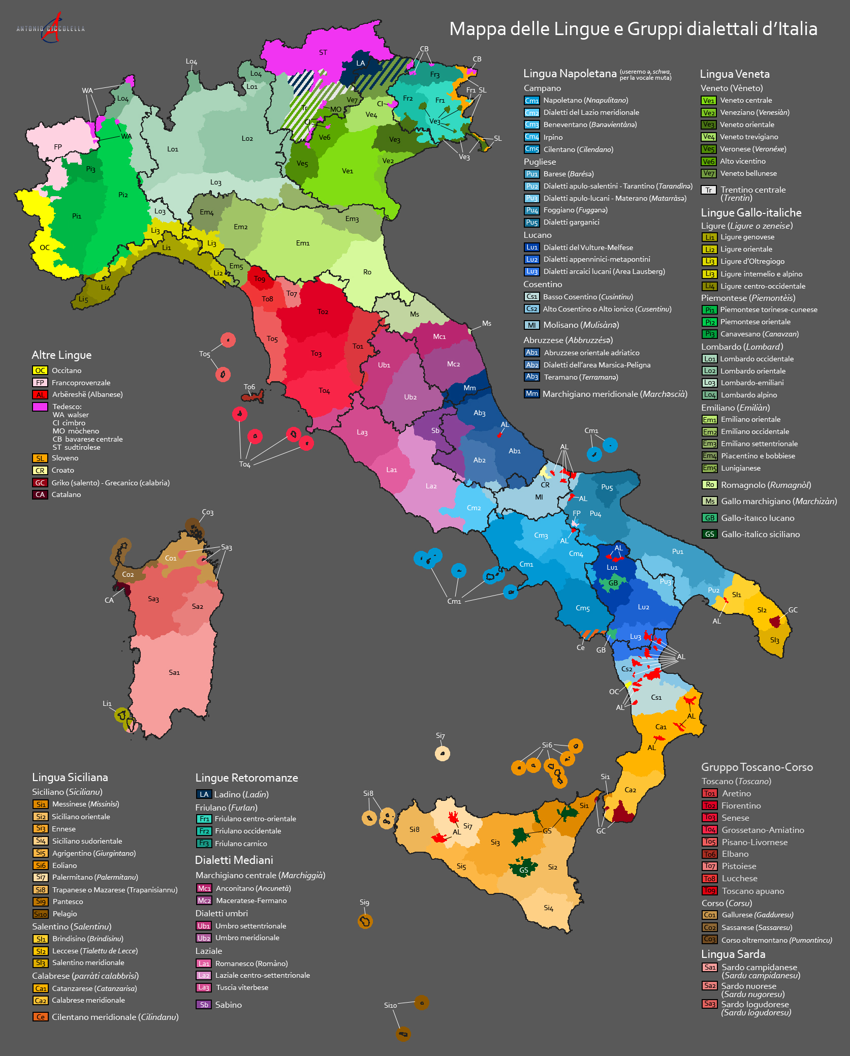
Many people don’t realise that Italy is linguistically diverse. When Latin was the most common literary language and the language of prestige, Dante Alighieri broke new ground in the 1200s with his published works, Commedia (Divine Comedy) being one of those. Instead of writing in Latin or French, he wrote in his local vernacular of Latin – Florentine. His written language style served as the foundation for developing a “formal standard” that all educated Italians could comprehend. Florentine gained prestige in particular partly because of the political and cultural significance of Florence, and because it was viewed as a linguistic midway between the northern and southern dialects. However, there were many other languages spoken on the peninsula and islands that had also developed from Vulgar Latin. These include Neapolitan, Venetian, Sicilian, and many more. Mappa delle Lingue e Gruppi dialettali d’Italia (Map of the Languages and Dialect Groups of Italy) attempts to represent those languages geographically.
Created by Antonio Ciccolella in 2015 and uploaded to Wikimedia Commons, the map shows the incredible number of regional languages spoken in Italy today, including some that arrived from outside (Arbëreshe from Albania, Griko and Calabrian Greek from Greece), and languages that straddle Italy’s borders where once no borders existed.
The map stands out with its striking colour palette that immediately pleases the eye. The labelling is also helpful in determining the smaller linguistic pockets. Unfortunately, some of these languages are endangered, and there are varying local efforts to preserve them.
The linguistic diversity of the Caucasus
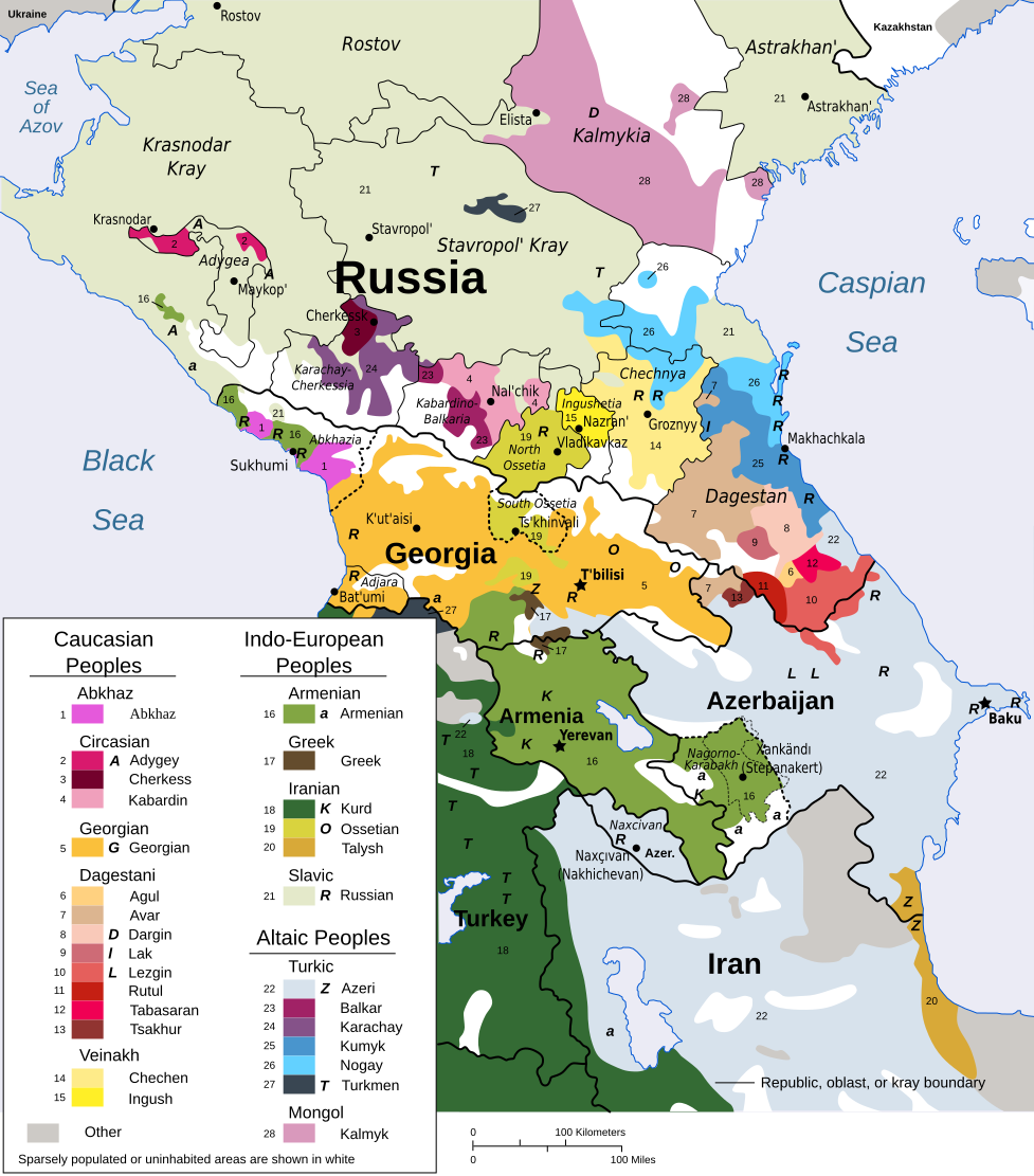
This is a vectorised version of a 1995 CIA map “Ethnolinguistic groups in the Caucasus region“, uploaded in 2007 to Wikimedia Commons by user Pmx, and further edited by other Commons users. Its accuracy is debated, but I have always been fascinated by this map.
It illustrates the incredible diversity of the Caucasus region, from northern Iran to southern Russia. There are varying people groups who live here, including Caucasian, Indo-European, Turkic, and Mongol, who speak dozens of different languages. One fun fact about some of the Caucasian languages spoken in this area (e.g. Abkhaz, Adyghe) is that their phonology often includes an extraordinary number of consonants, and only several vowels. The extinct Ubykh language has a record 84 phonemic consonants, and only three phonemic vowels.
NativLang on YouTube has a fantastic video about this region talking about the linguistic diversity and unique features of the languages here and also tries to answer WHY so many exist: The Caucasus: Mountains Full of Languages. He even uses this very map to illustrate his points!

Accuracy and precision
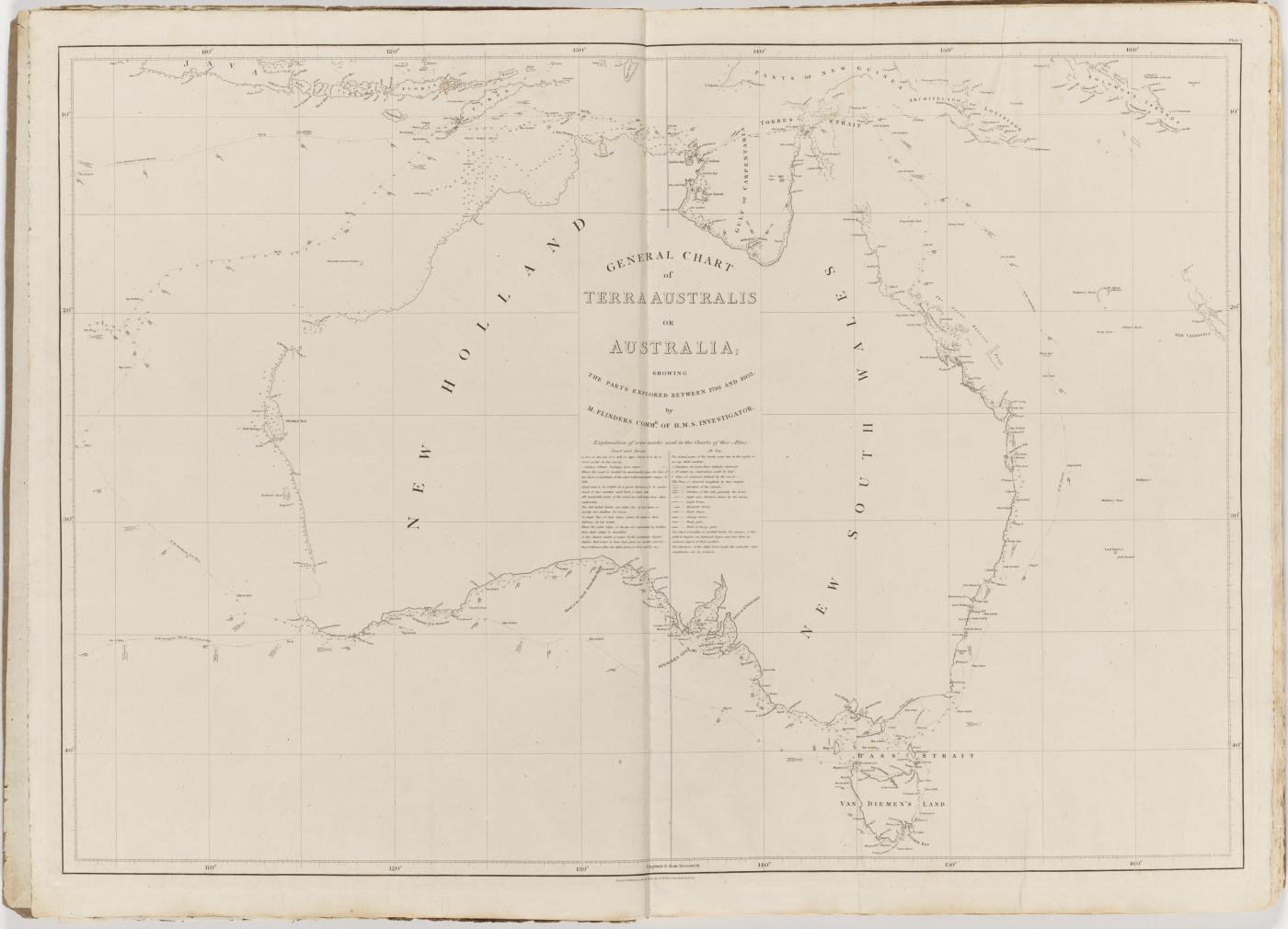
Matthew Flinders (1774–1814) was the first explorer to circumnavigate Australia. His major work, A voyage to Terra Australis and accompanying atlas, was published right before he died. His cartographic map of the continent was titled: General chart of Terra Australis, or Australia. It showed the parts explored by Flinders between 1798 and 1803. After Flinders had died, Phillip Parker King and other navigators made additions to this map, and published a second edition in 1822, filling in the coastline from Flinders’ original.
I have always been staggered by the beauty of both maps. The accuracy for its time is incredible. In Flinders’ day, coastlines were mapped using a special technique: first, the position of the ship was established by observing the sun, moon, and stars, the time of day, and a lot of arithmetic. Second, using a compass, lines were drawn on a map showing the direction of particular landmarks on the coast. The ship then moved to a new position, and the first two steps were repeated. If you look closely at Flinders’ charted maps, you can see the path of the ship and distances recorded. When you overlay a modern GIS shapefile of the outline of Australia onto Flinders’ maps, it is astounding how accurate and precise his measurements were for the time.
In 2014, I travelled to Canberra to attend an amazing exhibition at the National Library of Australia (NLA) entitled Mapping Our World: Terra Incognita to Australia. The exhibition showcased old and special maps from history, painting a picture of how the Australian landmass went from unknown to randomly appearing on maps over the centuries. One map loaned to the NLA was Fra Mauro’s famous mappamundi (1448-1453), the most important late medieval map in existence. It had never left Venice before, and it was a privilege to see it in person. Right at the very end of the exhibition was the 1822 map of Australia, Flinders’ map with additions. It was a great way to end, showing the culmination of countless explorers’ intense searches for the mysterious great southern land.